
Upper Pittsgrove, MT · Salem County
Woodland Data Form
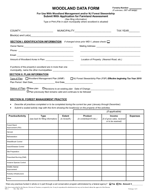
The Woodland Data Form reports forest management activities and plan information for owners seeking farmland assessment of non-appurtenant woodland in Upper Pittsgrove.
What this form is
Owners seeking farmland assessment for non-appurtenant woodland use this form to report property and plan details, forest management practices, and related income and expenses. File it with the annual Farmland Assessment Application; the form also calls for an activity map and, unless already on file with the assessor, a copy of the approved plan. The owner and approved forester certify the information and plan compliance.
Who needs it
A woodland owner seeking farmland assessment for non-appurtenant woodland must file this form with the Farmland Assessment Application.
How to submit it
File the form with the Farmland Assessment Application with the local tax assessor, and send the FA-1, WD-1, and activity map to the New Jersey Forest Service Southern Region, 5555 Atlantic Avenue, Mays Landing, NJ 08330.
About notarization
This document is signed and dated without a notary; the owner and approved forester each certify the form by signing it.
How to submit this form
- 1
Download The Form
Download the Woodland Data Form PDF.
- 2
Complete The Form
Enter the property, owner, plan, and forest management practice information requested on the form.
- 3
Gather Required Attachments
Prepare an activity map and include the approved plan or any revisions if required.
- 4
Sign And Submit
Have the owner and approved forester sign and date the form, then file it with the Farmland Assessment Application as directed.
Frequently asked questions
- Do I need a notary for the Woodland Data Form?
- No. This form is signed and dated without a notary. The owner and approved forester each sign to certify the reported information and plan compliance.
- How do I submit the Woodland Data Form?
- File it with the Farmland Assessment Application with the local tax assessor. Also submit the FA-1, WD-1, and activity map to the New Jersey Forest Service Southern Region at 5555 Atlantic Avenue, Mays Landing, NJ 08330.
- What attachments go with the Woodland Data Form?
- Submit a property map showing forest management activity. Include a copy of the approved plan unless the assessor already has it on file; submit any revisions to a plan on file.
- Who completes and signs the Woodland Data Form?
- The woodland owner provides property, plan, and management activity information. The owner and an approved forester each certify the form and sign and date it.
Need something notarized?
This Woodland Data Form doesn’t need a notary — but if you have another Upper Pittsgrove form that does, a commissioned online notary can help.