
Maggie Valley, NC · Haywood County
Floodplain Development Permit Application
Property owners or agents use this application to request a Town of Maggie Valley permit for proposed development in a floodplain.
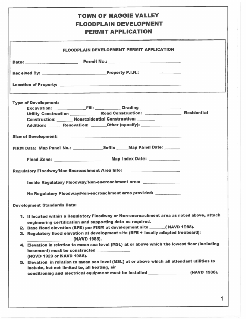
What this form is
This application requests a floodplain development permit and collects property, project, flood map, flood elevation, and construction details. The applicant provides information about the proposed development, elevation methods, and any watercourse changes. If the project is in a regulatory floodway or non-encroachment area, the form calls for engineering certification and supporting data; before occupancy, an elevation or floodproofing certificate must be on file.
Who needs it
A property owner or agent proposing floodplain development in Maggie Valley should complete this application and provide the requested project information.
How to submit it
Submit it to the city department named on the form; check the city website for current contact details. The form identifies the Planning Department.
About notarization
This application is signed and dated without a notary; supporting items may include engineering certification, an alteration description, and a later certificate signed by an engineer or registered land surveyor.
How to submit this form
- 1
Download The Application
Download the Floodplain Development Permit Application PDF.
- 2
Complete The Application
Provide the requested property, development, flood map, elevation, and construction information.
- 3
Gather Required Attachments
Attach engineering certification and supporting data if the project is in a regulatory floodway or non-encroachment area, and describe any watercourse alteration.
- 4
Sign And Date
The applicant or agent signs and dates the application.
- 5
Submit To The City
Submit it to the city department named on the form; check the city website for current contact details.
Frequently asked questions
- Do I need a notary for the Floodplain Development Permit Application?
- No. The application has signature and date lines but no notary block. It may require engineering certification or a later elevation or floodproofing certificate signed by a professional engineer or registered land surveyor.
- How do I submit the Floodplain Development Permit Application?
- Submit it to the city department named on the form; check the city website for current contact details. The form identifies the Planning Department.
- What information does the application request?
- It requests property and project details, flood map information, elevations, construction information, and the proposed method of elevating the structure.
- What attachments may be required?
- For development in a regulatory floodway or non-encroachment area, attach engineering certification and supporting data. If a watercourse will be altered or relocated, attach a description of the extent.
Need something notarized?
This Floodplain Development Permit Application doesn’t need a notary — but if you have another Maggie Valley form that does, a commissioned online notary can help.